
WYMONDLEY PARISH
ENVIRONMENTS
Greenbelt
green infrastructure
transport links
TRAFFIC management
education
telecommunications
local business
well-being
housing
NEXT STEPS
GET INVOLVED
ANNEX
Flood risk
Aim
To contribute to the well-being of the Parish by seeking to address the current shortfall in Flood Prevention Measures; and to work constructively with local planning authorities to pre-empt the future effects of climate change and ensure that any development proposals are sustainable, have no adverse effect on potential flood risk and will contribute to existing and necessary future infrastructures.
Background
The landscape and topography of the land comprising and surrounding Wymondley Parish was sculpted and formulated by the advance and retreat of some twenty or so Ice Ages during the Pleistocene Era.
Since then, of course, there have been interventions and changes wrought by man. For example, the construction of the London to Scotland railway; the Great North Road; its conversion to the A1(M) and, latterly, the A602 Wymondley Bypass have all crossed or used the Wymondley Valley - in some cases altering the topography of the area through their construction.
Wymondley Parish is essentially an old river valley, with Little Wymondley occupying the lower portion of the valley. Great Wymondley lies to the north, on slightly higher ground, and the hamlets of Todds Green, Titmore Green and Redcoats Green are to the south – again, on slightly higher ground.
The geological map below, (and the Environment Agency flood map of the same area which accompanies it), show the surface geology of the area and illustrate the flood route. The areas shown in yellow on the geological map, (which are Glaciofluvial deposits of mid Pleistocene sands and gravels), follow the course of Ash Brook from Graveley, through Corey’s Mill and Little Wymondley, to join further tributaries of the River Purwell at Ninesprings.
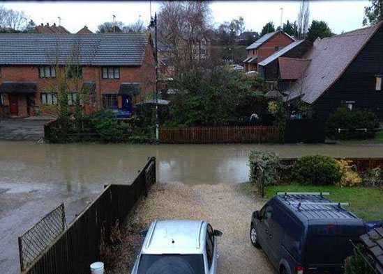
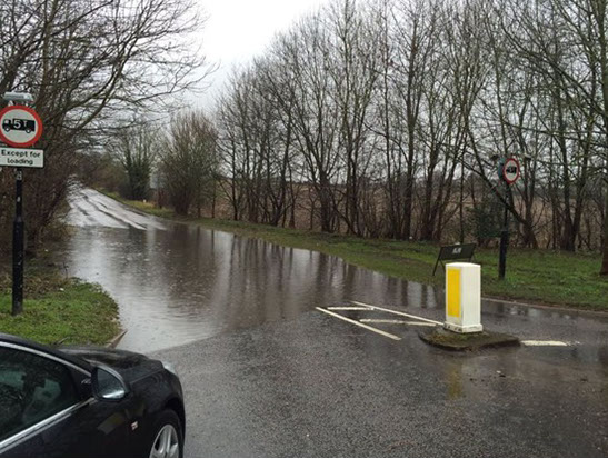
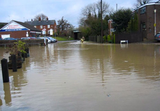
The photographs which follow the maps show examples of flooding in Little Wymondley.
Over recent years, (most notably in February 2014 and on 8 March 2016), the risk of flooding in Little Wymondley has become increasingly apparent - with greater disruption caused to properties in 2014 than in past years. The floods followed exactly the path of Ash Brook - and demonstrated the effects both of intervention by man, and the lack of maintenance of existing flood control measures during times of spate.
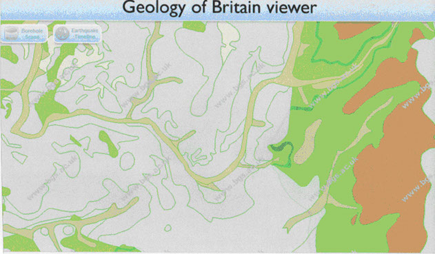
Wymondley geological map
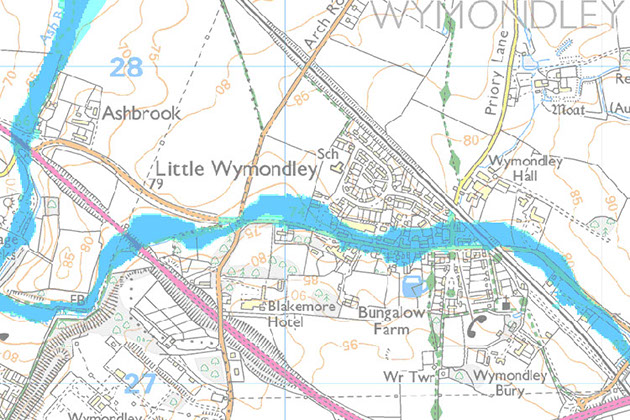
Wymondley flood map
Siccut Road, near Stevenage Road, Little Wymondley 1968
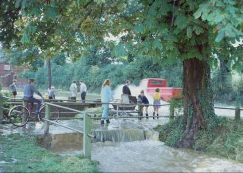
Priory Lane, Little Wymondley 1968, looking up the Lane
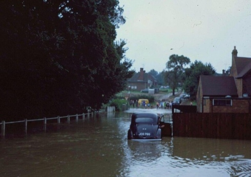
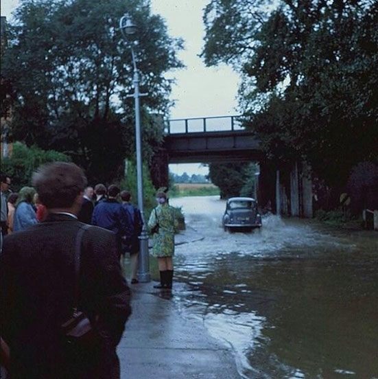
Priory Lane, Little Wymondley 1968, near the Plume of Feathers, looking towards Stevenage Road and Tower Close
Priory Lane, Little Wymondley 2014, the same location 46 years later
As a consequence of the 2014 flood, Hertfordshire County Council (HCC) commissioned a report into it. On 22 October 2015 it presented its findings to residents, business owners and other interested parties at a public meeting at Wymondley JMI School.
Opinions voiced there, and in response to our Parish survey carried out in July 2015, left stakeholders in no doubt as to the impact of the 2014 flood, and the level of importance parishioners attach to alleviating the flood risk; improving and properly maintaining the current Parish infrastructure; and ensuring that the consequences of any future development are properly and realistically assessed and accounted for in any such proposals.
The HCC Flood Investigation Report on the Little Wymondley flood and the associated Flood Alleviation Feasibility Study on Little Wymondley, undertaken for HCC by McCloy Consulting Ltd are attached as pdf documents and available online at:www.wymondley.org They clearly illustrate the inadequacies of the current installed system and its state of repair, notwithstanding that they failed to take into account the run-off from the southern side of the valley.
It can readily be seen that developments that could increase the strain on an already damaged, (and demonstrably inadequate), existing system should be implemented with no increase in risk or, preferably, reduce the existing problem.
Socio-economic impact
72% of survey respondents had concerns about flooding in the Parish, wanting to see improvements to flood risk management and drainage. Unsurprising, given the physical, emotional and economic impact of your home or business being subject to flooding; or affected by flooding to neighbouring roads and land, and related loss of access; or loss of telecommunications. Insurance cover, loss of revenue, additional costs and inconvenience come hand in hand with flooding risk. (The Plume of Feathers P.H. in Little Wymondley, for example, was flooded in 2014 causing £40,000 worth of damage, and cannot now obtain insurance.)
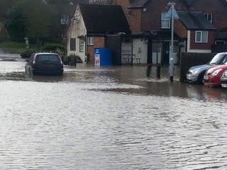
Flooding along Stevenage Road, Little Wymondley, February 2014
Little Wymondley Flooding, 9 March 2016 - Arch Road/Stevenage Road Junction
Horse riding is a very popular activity in the area, with a number of equestrian businesses in the Parish - as well as privately owned horses. Consequently, horse grazing fields are a common feature of our parish landscape, and flooding is a serious issue for them - not only in terms of loss of grazing, (and the resulting increased cost of providing replacement feed and bedding), but also in relation to access to, and condition of, fields and bridleways.
There is an economic impact, for example the knock-on effect on customers of increased livery and lesson prices, and inability to access stables etc, which may lead to loss of business – particularly in relation to businesses located near Priory Lane or Stevenage Road in Little Wymondley. It could also be argued that disabled riders might be disproportionately affected, as the Stevenage Riding for the Disabled Association (RDA) uses Courtlands Riding Stables’ ponies on a weekly basis. The Stables is situated off Chantry Lane in Todds Green, with fields adjacent to the Stevenage Road in Little Wymondley, which are prone to flooding.
Priory Lane, at the Junction with Stevenage Road, February 2014
As well as the domestic and business disadvantages of flooding, there are also repercussions for recreational activities in the Parish. Construction of the Multiple Use Games Area (MUGA) on the Queen Elizabeth II Playing Fields in Little Wymondley, for example, has exacerbated the pre-existing problems with flooding there - resulting in complaints about waterlogged and unplayable football pitches (and associated revenue and other consequences); and flooding on the MUGA itself on occasions.
Given the size of the MUGA, we can only wonder what the potential flooding impact would be of a large-scale housing development in the immediate vicinity, such as that proposed by NHDC and known as WY1 ; or of proposals for an industrial estate on a flood plain adjacent to the village, as proposed by Stevenage Borough Council in its draft Local Plan. We raised our concerns when the proposals were first mooted, and our discussions with the relevant authorities are ongoing.
8.16 Our petanque teams are similarly concerned about flooding, particularly in relation to the Little Wymondley pistes. If the pistes flood, (as they have done in the past), it has a detrimental effect on players’ ability to participate in both social and league matches – and ultimately on individual/team performance and success.
As the premier stakeholder in this matter of flood risk evaluation for Wymondley Parish, our Neighbourhood Plan is intended to assist in developing sustainable and justifiable plans which could impact upon the flood risk to Wymondley. The well-being of our community is our primary consideration, and we would be failing in the stated aims of this Plan if we did not seek to address local concerns and remedy the situation. Our flood risk policies reflect this:
Policy FR1: We will rigorously pursue the need for implementation (and regular maintenance) of satisfactory Flood Prevention Measures in the Parish, particularly in relation to Little Wymondley.
Policy FR2: We will continue to work with HCC to develop a SWMP for the Parish. We view this as particularly important, given the absence of a SUDS policy in relation to Stevenage Road in Little Wymondley, notwithstanding the fact that it follows the natural contour of an Ice Age river bed.
Policy FR3: We will work constructively with local planning authorities, flood authorities, and other stakeholders, to ensure that any development proposals are sustainable and address local concerns regarding exacerbation of flood risk.
Policy FR4: We will robustly oppose any proposed development that fails to address the required infrastructure implementation needed to mitigate and reduce flood risk to our community.
When considering development in an area such as Wymondley Parish, where the flood risk is high and there are major implications for residents and business arising from inadequate drainage and other Flood Prevention Measures, we believe it is essential that proposals comprehensively assess issues such as water run-off down roadways – and include adequate provision for their management and control.
There is currently no legislative requirement in England and Wales for designers and planners to consider, in an urban context, the interaction between drainage and roads – and ensure that adequate measures are taken to protect roads’ structural integrity and address related issues. In Scotland, however, regulators, enforcement agencies, and other stakeholders have seen the light and through partnership working have produced practical guidance on the application of Sustainable Urban Drainage Systems (SUDS) to road design – a key factor in achieving sustainable long-term environmental and social improvements.
When taken as part of a holistic flood risk and water management process, incorporating Strategic Flood Risk Assessments (SFRAs) and Surface Water Management Plans (SWMPs) , SUDS help create a vital tool for local organisations to develop a shared understanding of, and ability to manage, local flood risk. This includes setting out priorities for action, maintenance needs and links into Local Development Frameworks and Emergency Plans.
Annex 5 provides a brief explanation of the critical relationship between rainfall, surface water flooding and drainage – and the need for joined-up working by stakeholders to properly assess and manage flood risk. More comprehensive information is contained in the DCLG Planning Guidance on SFRAs, the DEFRA technical guidance on SWMPs, and the Scottish guidance on SUDs.
Policy FR5: We believe an integrated, risk-based approach to flood risk management is the way forward, and strongly support the inclusion of Sustainable Urban Drainage Systems (SUDS) in any development proposal. We will work positively with local authorities and other stakeholders to ensure they are fully considered from the design stage onwards; and that development proposals include (and implement) measures to satisfactorily address issues highlighted in SFRAs and SWMPs.
Until now, it has been demonstrably apparent that our planning system has stratified responsibilities to such an extent that project planners are absolved of any responsibility to address infrastructure problems and costs arising from implementation of their plans. We are hopeful that the recently introduced concept of “locality”, (which allows communities and people most affected by planning and development decisions to have their say at Neighbourhood Plan level), will ensure that, from the beginning, adequate infrastructures are discussed, planned and implemented.