
WYMONDLEY PARISH
ENVIRONMENTS
Greenbelt
FLOOD risk
green infrastructure
transport links
TRAFFIC management
education
telecommunications
local business
well-being
housing
NEXT STEPS
GET INVOLVED
Annex
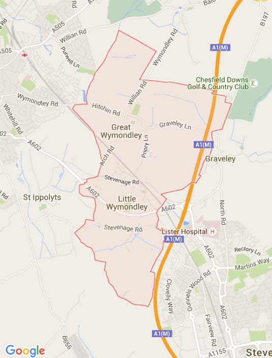
Annex 1
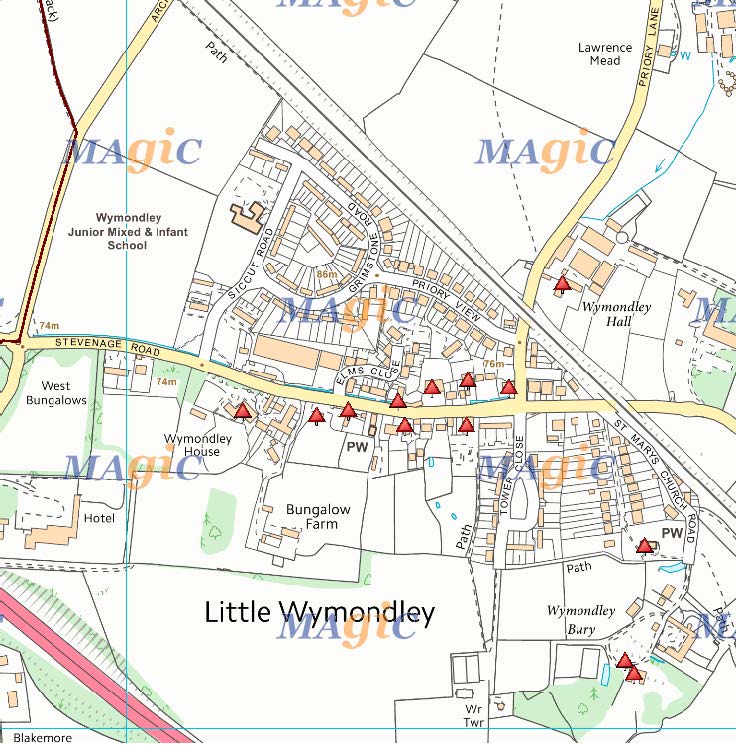
Wymondley Parish Map
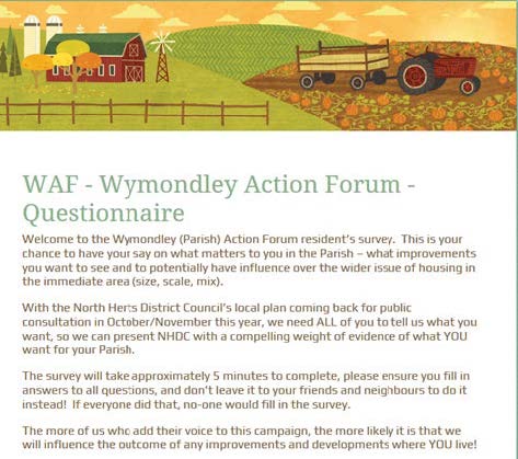
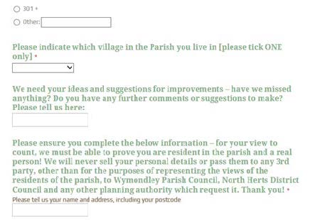
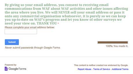
Annex 2
Wymondley Action Forum (WAF) Parish Survey Form

Annex 3
Key Points of Archaeological Interest in the Parish
Wymondley Parish North
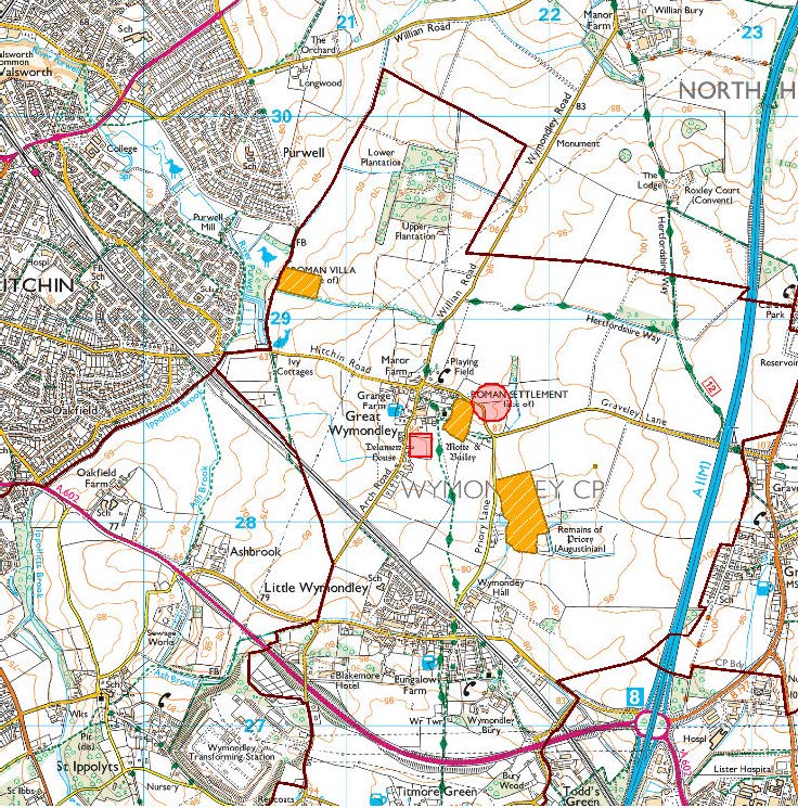
(c) Crown Copyright and database rights 2016. Ordnance Survey 100022861
Wymondley Parish Central
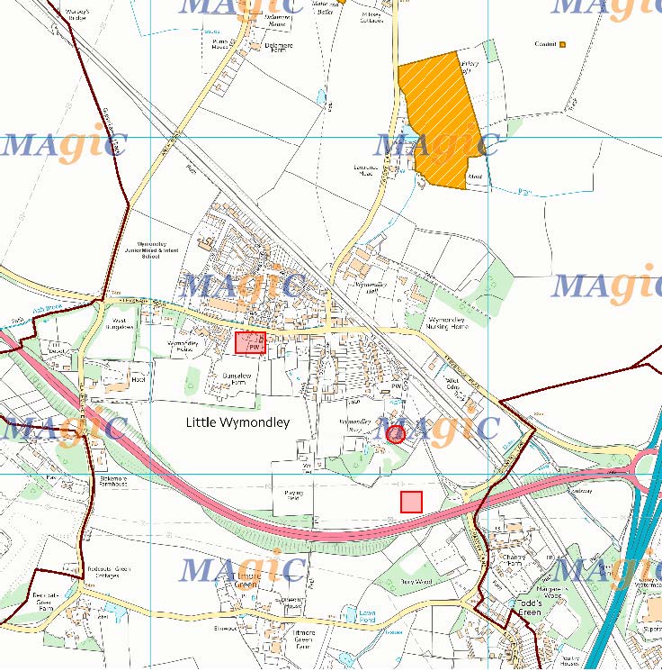
(c) Crown Copyright and database rights 2016. Ordnance Survey 100022861
Wymondley Parish South
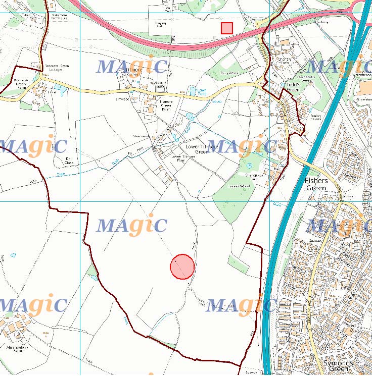
(c) Crown Copyright and database rights 2016. Ordnance Survey 100022861
Habitation Timeline
A. The Parish has been periodically inhabited since the Stone Age, 435,000 years ago. Flint tools have been found.
B. Mesolithic occupation 11,000 years ago. Some ‘microliths’ found in Great Wymondley, including part of sophisticated modular hand tools.
C. ~6,000 BC - the population became more settled, evidenced by hazel plantings nearby, plus a ‘’Tranchet’’ hand axe found at Great Wymondley. There are also two ring ditches surrounding burial sites, (one just outside the Parish, the other at Titmore Green). At the same period an ovoid Neolithic Henge (Marked 9 on Map Wymondley Parish South) was constructed at Lower Titmore Green. It is archaeologically marked as a ‘Grade One Henge’, i.e. significant, and has been safeguarded by NHDC. The ditch is on the inside of a raised bank - not defensive, but religious or recreational.
D. A stone mould from the same period, used to make socketed gauges, was found during the construction of the Wymondley Bypass in 1992.
E. Roman occupation was pretty extensive in the area. Wymondley Parish is just off the main Roman Road North and there may also have been one running diagonally across the land, from the Stevenage settlement to Hitchin (Hicce).
There was a Roman Villa (Marked 1 on Map Wymondley Parish North) by Gipsy Lane/Purwell, which was partially excavated in 1882, but may be much more extensive than what has so far been found.
There was also a Roman cemetery just north of the Church in Great Wymondley, by the playing field, and it is likely that there would have been a settlement close by. This was probably built over when Hitchin Rural District Council built its Council houses there in the 1930’s (Marked 4 on Map Wymondley Parish North). A number of Roman objects were found during foundations excavation.
In 1990 prior to the bypass being started a survey found remains of a large building south of The Bury (Marked 7 on Map Wymondley Parish Central) in Little Wymondley. This was probably two-storey and with some tessellated flooring and tiled roof ~100 AD; extended in ~150 AD, but abandoned in ~250 AD. It was robbed out, except for a ‘cottage house’ on the site, for materials for a new Romano-British building north of the pylon.
F. There are two Wymondleys, probably because of two Roman villas. The field system carried on after the Romans left.
Secondary settlements by Saxons etc. include the ‘greens’ of Todds, Titmore and Redcoats. (....ley is a corruption of Old English ‘Leah’ - a woodland clearing - hence ‘Wilmond’s Clearing.) We were mostly woods during Saxon occupation.
G. The Normans arrived after 1066 and were prolific in this area, following the English surrender at Berkhamsted. The Normans built a castle at Great Wymondley (Marked 2 on Map Wymondley Parish North), to guard the main road north and east-west route. The early one was wood, then stone later - but robbed out. With the Normans came the priests, evidenced by the Priory (Marked 3 on Map Wymondley Parish North5) and both St Mary’s Churches.
H. Medieval and somewhat later dwellings include Delamere (Marked 5 on Map Wymondley Parish South) and The Bury (Marked 6 on Map Wymondley Parish South); also two C14th cottages on the Stevenage Road (Boro Cottages). The land at the rear (Marked 8 on Map Wymondley Parish Central) is also of archaeological significance.
KEY TO MAPS
SITE NO. DESCRIPTION. MAP NAME.
1 Roman Villa Wymondley Parish North
2 Motte & Bailey Wymondley Parish North
3 Augustinian Priory Wymondley Parish North
4 Roman Settlement Wymondley Parish North
5 Delamere House Wymondley Parish North
6 Wymondley Bury Wymondley Parish Central
7 100 -150 AD House Remains Wymondley Parish Central
8 Borough Cottages Wymondley Parish Central
9 Neolithic Henge Wymondley Parish South
Annex 3
Listed Buildings in Great and Little Wymondley
Great Wymondley, Listed Buildings.
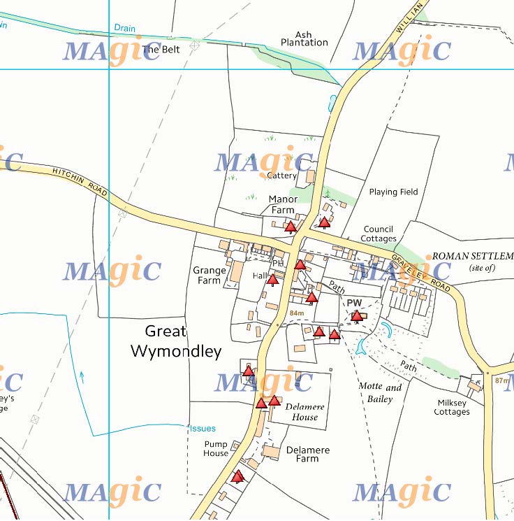
(c) Crown Copyright and database rights 2016. Ordnance Survey 100022861
Little Wymondley, Listed Buildings.
Annex 5
Surface Water Management Plans – The Importance of an Integrated Regional Drainage Strategy
1. Surface water flooding frequently develops quickly and can be difficult to predict. Flooding occurs when man-made and natural drainage systems have insufficient capacity to cope with the amount of rainfall. The critical factors for surface water flooding are the volume of rainfall, the rainfall intensity and the permeability of the surface onto which the rainfall falls. In urban areas where the ratio of impermeable surfaces to vegetated areas is high, sudden and intense rainfall drained through conventional drainage piped systems designed to remove surface water from a site as quickly as possible, can lead to downstream flooding problems.
2. The urban drainage system is a complex interaction of the urban landscape including buildings, roads, public sewers, private sewers and watercourses. The integrated approach by partners and stakeholders in the preparation of Surface Water Management Plans (SWMPs) will give the roads authorities clear roles where the roads form a key part of the drainage or alleviation of flood risk, namely:
- Retain data relating to location and serviceability of existing road drainage; and
- Design road drainage to minimise surface water run-off.
3. SWMPs should be referred to in planning policy as a tool to manage surface water flood risk on a local basis by improving and optimising coordination between relevant stakeholders. SWMPs build on Strategic Flood Risk Assessments (SFRAs) and provide the vehicle for local organisations to develop a shared understanding of local flood risk, including setting out priorities for action, maintenance needs and links into local development frameworks and emergency plans.
4. The purpose of the SWMP is to make sustainable urban surface water management decisions that are evidence based, risk based, future proofed and inclusive of stakeholder views and preferences.
5. The key aims of the SWMP are:
a) Ensuring that development allocations within an area are properly supported by adequate surface water management; and
b) Providing a common framework for stakeholders to agree responsibilities for tackling existing drainage problems and preventing future problems.
c) Where development pressures are high it can be part of a Water Cycle Strategy
d) Demonstrating how capital investment, infrastructure and maintenance can deliver the required surface water management
6. The SWMP considers the regional management of surface water under a full range of rainfall events, from short, high intensity rainfall events that impact on water quality to the longer duration infrequent events that may generate overland flood flows.
7. Central to a risk based surface water management approach is the prediction of the occurrence and frequency of flooding events. Provision should be made in relation to the following areas:
- Coordination and cooperation within the domain of flood risk management;
- Assessment of flood risk and preparation of flood risk maps and flood risk management plans;
- Amendments to local authority and Environment Agency functions for flood risk management;
- A revised statutory process for flood protection schemes; and
- Amendments to the enforcement regime for the safe operation and monitoring of flood
and surface water attenuation areas.
Annex 6
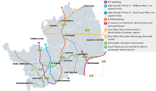
HCC Potential Long-term Transport Links
Long Term – Urban Extensions & Densification
What transport schemes would be needed for the long term if growth is concentrated in and around Hertfordshire’s existing urban areas through large-scale urban extensions, and more dense forms of development?
Annex 7
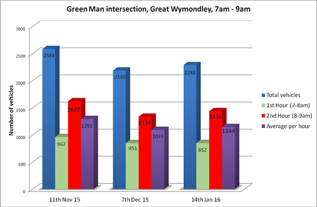
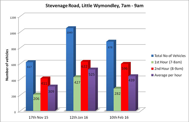
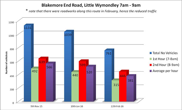
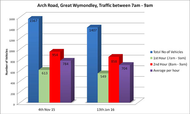
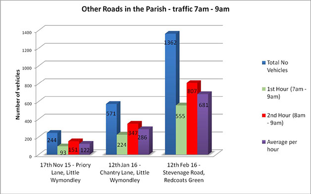
Wymondley Parish Traffic Survey Results 2015/16
Annex 8
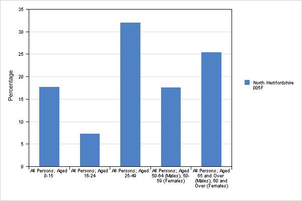
Wymondley Parish Demographic according to the 2011 census
Neighbourhood Definition
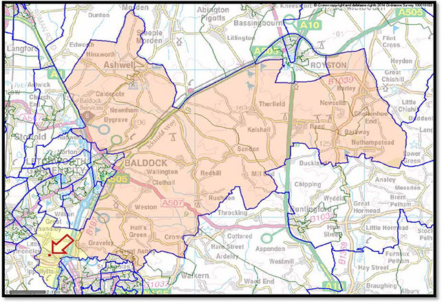
Your neighbourhood contains roughly 1600 people or 670 households. The Office for National Statistics calls these neighbourhoods ‘Lower Layer Super Output Areas’ (LSOAs). The area covered by the ONS report is designated 005F with North Hertfordshire.
The area highlighted yellow is representative of the data set used in the 2011 census, which is larger than Wymondley Parish.
Mid-2011 population estimates
Variable
All people
Males
Females
Measure
Your area
Your neighbourhood
Count
Count
Count
1,392
667
725
14,828
7,343
7,485
Percentage of people in each age band in your neighbourhood, mid-2011
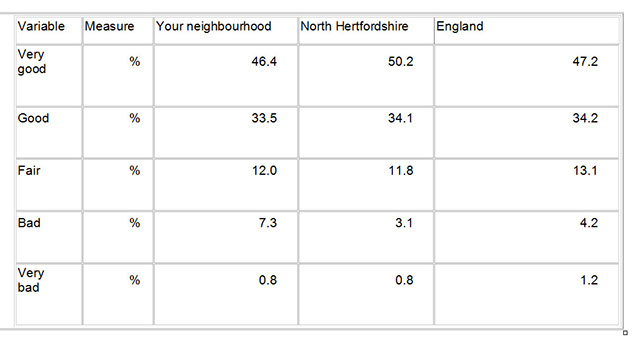
People's general health, March 2011
Economic activity in your neighbourhood, March 2011
The 2011 Census asked people about their working lives
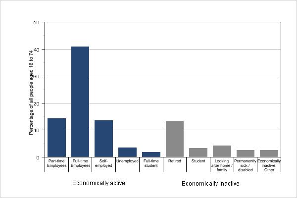
Note:
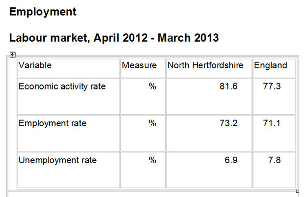
1. The Local Economy tab of this Neighbourhood Summary shows overall employment, unemployment and economic activity rates, taken from the most recent official sources. The chart, above, supplements this information, showing further detail, as recorded at the time of the 2011 Census. The figures are not directly comparable, due to the different time periods.
1. Part-time employees worked 30 hours, or less, a week.
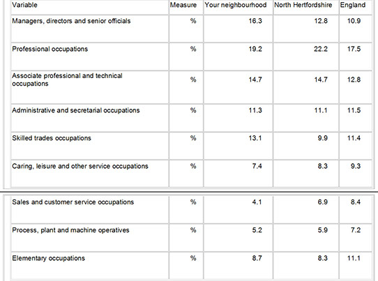
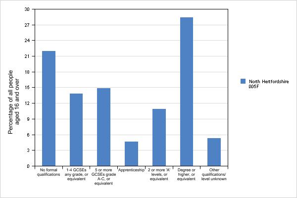
Qualifications held by people in your neighbourhood, March 2011
The chart, below, shows percentages of people aged 16 and over in your neighbourhood by their highest qualification.
Household composition in your neighbourhood, March 2011
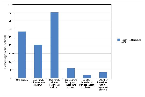
People were asked in the 2011 Census about what kind of dwelling they were living in at the time. The chart, below, shows the percentage of different types of accommodation in your neighbourhood.
Accommodation type in your neighbourhood, March 2011
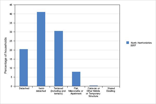
Note:1. All dwellings are unshared unless stated otherwise. Detached, semi-detached and terraced refer to houses or bungalows. Dwellings by tenure, April 2011
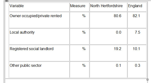
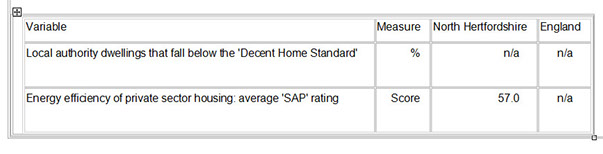
Housing condition, April 2011
Decent Home Standard (DHS) - each local authority uses this to measure the general standard of its dwelling stock.
Standard Assessment Procedure (SAP) Rating - the Government's approved procedure for calculating an energy rating. The measure ranges from 1 (highly inefficient) to 100 (highly efficient).
Annex 9
Fire Safety Department
ACCESS FOR APPLIANCES AND FIRE-FIGHTING FACILITIES FOR FIRE & RESCUE SERVICE USE
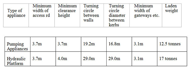
REQUIREMENTS FOR ACCESS ROADS
ROAD WIDTHS
Access roads may be public highways, private roads, footpaths or specially strengthened and defined routes through the land surrounding the building(s). The requirements for pumping appliances and hydraulic platforms are as follows:
ACCESS FOR A HYDRAULIC PLATFORM
Where access for a hydraulic platform is specified, the roadway should be positioned with its nearest edge a maximum of 2 metres from the face of the building and its furthest edge a minimum of 7.5 metres from the building. This will enable the appliance to operate at its optimum height and reach, (see Diagram 1, App III). Roads, including any manhole covers and public utility service pits, should be capable of carrying the weights set out above for the respective appliances.
Hardstanding for Hydraulic Platforms should be as level as possible, and should not exceed a gradient
of 1 in 12(8%).
TURNING AND SWEEP CIRCLES OF APPLIANCES
When providing access for appliances, allowance should be made for a pumping appliance's turning circle of 16.8m diameter, and sweep circle of 19.5m diameter. Hydraulic platforms have a turning circle of 29.0m diameter with a sweep circle of 29.0m diameter. Additional turning space should be provided where corners have to be negotiated, and sweep circles should not be obstructed above kerb height.
Appendices I and II show the other relevant details of pumping appliances and hydraulic platforms. Although the diagrams show transition curves for travel in one direction only, it should be remembered when planning suitable turning and sweep circles that the curves need to be repeated in the opposite direction.
CUL-DE-SAC
Turning facilities should be provided on cul-de-sac roads exceeding 20m in length by means of a turning circle or a hammerhead.
OBSTRUCTION TO ACCESS
All access roads for Fire & Rescue Service appliances should be kept clear of any obstructions, including trees, lamp standards, etc. It may, however, be considered necessary to restrict unauthorised entry and various arrangements are set out below.
Before any obstructions are installed the proposed arrangements should be agreed with the Fire & Rescue Service.
POSTS AND BOLLARDS
Siting of bollards must not obstruct the use of hydrants.
(a) Fixed and removable posts or bollards
When considering the type of post or bollard to be used, either fixed or removable, it is particularly important to bear in mind the type of scheme being considered.
If the scheme is a simple environmental improvements scheme in a thoroughfare it may be acceptable for a row of fixed bollards to be spaced along the kerb line. If this is not acceptable to the traffic authority, there are a number of options:
(i) Intermediate bollards of a 1ower height, i.e. below 230mm in height.
(ii) A removable bollard - one only for any access route. Removable bollards may be of galvanised steel tube and of the standard design. They should be secured in position with a standard padlock.
(b) Collapsible posts or bollards
Collapsible posts and bollards are acceptable in certain cases provided they do not project more than l50m above ground level when folded and are not of such a type that an appliance passing over one end of the collapsed bollard will raise the other end and foul the appliance. Collapsible posts may be of iron, pivoted near the ground. They should be secured by a standard padlock.
(c) Flexible posts or bollards
Any proposal to use flexible bollards of a new or improved design should be referred (with particulars of the design) to Fire and Rescue Service Headquarters, Old London Road, Hertford.
The design should incorporate features that prevent damage occurring to fire appliances.
They should not be used in conjunction with any other scheme
SPEED CONTROL HUMPS
Speed control humps (these may sometimes alternatively be referred to as 'sleeping policemen', 'speed retardant humps' or 'road ramps') are generally not accepted, but where they form part of a traffic management scheme their installation should be considered on their merits.
PEDESTRIANISED AREAS/TRAFFIC CALMING SCHEMES
Local authorities are increasingly making alterations to certain areas of towns and villages for reasons of road safety and to try to enhance the appearance of the areas. Included within these schemes are pedestrianisation of high streets and shopping areas, and 'traffic calming' at certain accident problem areas. Some of these schemes may affect attendance times by slowing down appliances dramatically on through routes, or prevent access into areas where they may be required. It is important that they do not impede appliances unnecessarily.
Schemes should meet the following criteria:-
(a) A clearly defined fire path at least 3.7m wide, and capable of supporting the weight of a Service appliance, i.e. minimum 17 tonnes, is required through a pedestrianised area. (This may be indicated by the use of different coloured concrete or different paving patterns). Where tall buildings abut, the fire path will need to be 5.5m wide for use by hydraulic platforms as per diagram 2 in Appendix III.
(b) The siting of the fire path should take into account building design features, e.g., canopies, extended shop fronts, etc. (these features may affect the positioning and operational use of hydraulic platforms and/or extension ladders).
(c) No seating, trees or flower beds should obstruct the fire path and no street furniture,
e.g. , lamp posts, should be allowed which could foul the ladders, etc. , on appliances.
(d) If appliance access to a pedestrianised area crosses a kerb, it should be ramped with a steady incline for a minimum length of 500mm with the difference in levels not exceeding 100mm and both ends inset.
(e) Any raised platforms should be at least l4m in length to prevent the grounding of hydraulic platforms.
(f) Corner blips should not obstruct fire appliances that may need to negotiate the corner (see Appendix I and II).
(g) Width restrictions should be a minimum of 3.7m, and have a "straight" approach on either side.
(h) The provision of passing bays on roads reduced to a single lane will mean that in the event of an incident occurring parked fire appliances will not immediately close the road.
(i) Chicanes must be capable of being negotiated by hydraulic platforms and pumping appliances, and have a "straight" approach on eitherside.
(j) Speed tables should conform to (e)above.
STANDARD PADLOCKS
These are suitable padlocks for the purpose of securing bollards or posts, but must be capable of being cut open in an emergency with the bolt croppers carried on Hertfordshire Fire appliances.
ACCESS TOBUILDINGS
ALL BUILDINGS NOT FITTED WITH FIRE MAINS Access should be provided in accordance with Table 1 below:-
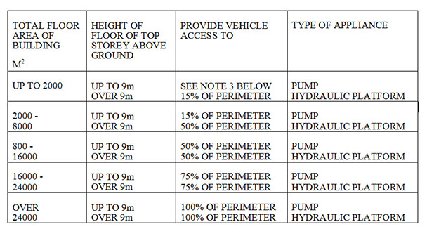
NOTE 1 The TOTAL FLOOR AREA is the appropriate aggregate of all the floors in the building.
NOTE 2 In the case of PURPOSE GROUP 7(a) (Storage) buildings height should be measured to mean roof level, as defined in Diagram C3 to Appendix C of Approved Document B to the Building Regulations1991.
NOTE 3 There should be vehicle access to small buildings (those up to 2000m²) with a top storey less than 9m above ground level) to within 45m of any point on the projected plan or "Footprint" of the building (See diagram 1 Appendix IV).
NOTE 4 Any elevation to which vehicle access is provided in accordance with TABLE1 should have a suitable door (not less than 750mm wide) giving access to the interior of the building.
BUILDINGS FITTED WITH DRY FIREMAINS
There should be access for a pumping appliance to within 18m of each fire main inlet connection point. The inlet should be visible from the appliance.
BUILDINGS FITTED WITH WET FIREMAINS
There should be access for a pumping appliance to within 18m, and within sight of, a suitable entrance giving access to the main and in in sight of the inlet for the emergency replenishment of the suction tank for the main.
(NOTE To 3.2 and 3.3 see also Standard Forms 3/2/1/1 and 3/2/2/1)
Appendix I
DETAILS OF PUMPING APPLIANCES
Maximum length 8.5m
Maximum height 3.3m
Maximum width 2.3m
Maximum weight 12.5tonnes
Maximum weight front axle 5.5tonnes
Maximum weight rear axle 6.1tonnes
Maximum length wheelbase 3.81m
Track rear wheels 2m
Ground clearance 229mm
Turning and sweep circles
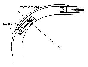
Width of roadway .........................3.7m
Turning circle.............................16.75m
Sweep circle ................................18.3m
This diagram shows the path of the appliance and is not intended to indicate kerb lines.
Appendix II
DETAILS (AT MAXIMUM) OF HYDRAULIC PLATFORM
Maximum length.....................................10m
Maximum height.....................................3.5m
Maximum width....................,.................2.5m
Maximum width with jacks out................4.4m
Laden weight...............................18.00 tonnes
Average weight front axle.................. 7 tonnes
Average weight rear axle................. 11 tonnes
Maximum length wheelbase................... 5.33m
Track rear wheels.. .................................... 2m
Minimum ground clearance ................. 229mm
NOTE: Overhang of booms on headrest do not exceed 1.83m from foremost part of the vehicle. Hydraulic platforms are fitted with four ground jacks as stabilisers. Under normal working conditions the weight on a jack should not exceed 7.5 tonnes.
Turning and sweep circles
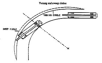
The diagram shows the path of an appliance and is not intended to indicate kerb lines.
Width of roadway............................ 6m
Turning circle.............................20.12m
Sweep circle ............................... 24.5m
Appendix III
RELATIONSHIP BETWEEN BUILDING AND HARDSTANDING/ ACCESS ROADS FOR HYDRAULIC PLATFORMS.
DIAGRAM 1
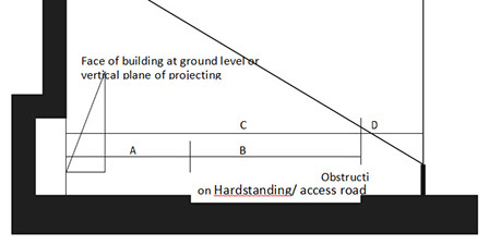
A. Minimum distance of near edge of hardstanding from building. 2.0m
B. Minimum width of hard standing. 5.5m
C. Minimum distance of further edge of hard standing from the building 7.5m
D. Minimum width of unobstructed space (for swing of appliance platform) 2.2m
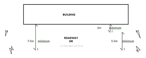
DIAGRAM 2
Appendix IV
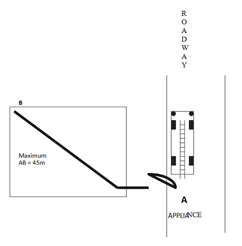
DIAGRAM 1
Annex 10
Consultation List
In developing our Neighbourhood Plan we have consulted the following statutory and non-statutory consultees, who we believe may have an interest in the policies it contains:
• Wymondley Parish residents
• Wymondley Parish businesses
• Wymondley Parish Council
• Local landowners and developers
• Wymondley Parish places of worship
• Gravely Parish Council
• St Ippolyts Parish Council
• Hitchin Forum
• Hertfordshire County Council
• North Hertfordshire District Council
• East Hertfordshire District Council
• Welwyn and Hatfield District Council
• Stevenage Borough Council
• biz4Biz
• Hertfordshire Local Enterprise Partnership
• Hertfordshire Chambers of Commerce
• Federation of Small Business
• North Herts Partnership (LSP)
• Homes and Communities Agency
• North Hertfordshire Homes (NHH)
• Campaign to Protect Rural England
• Natural England
• Environment Agency
• English Heritage
• Friends of Forster County
• Letchworth Garden City Heritage Foundation
• North Herts Action Group
• Wymondley Action Forum
• Open Spaces Society
• Save Our Green Belt
• Sport England
• Stevenage Riding for the Disabled Association
• Ramblers’ Association
• North Herts Ramblers’ Group
• Hertfordshire and North Middlesex Ramblers
• East Herts Ramblers
• Herts Natural History Society
• Herts and Middlesex Wildlife Trust
• British Horse Society
• Stevenage and North Hertfordshire Cycling Touring Club....
• National Allotments Society
• Network Rail Infrastructure Limited
• Virgin Trains East Coast
• Great Northern Rail
• Highways Agency
• Hertfordshire Police
• Hertfordshire Fire and Rescue Service
• Broadband Delivery UK
• British Telecom
• Openreach
• Sky
• Virgin Media
• E.on
• British Gas
• Eastern Electricity
• North Herts Health and Well-being Partnership
• East and North Herts NHS Trust
• Affinity Water
• Anglian Water
• Thames Water
• Rt Hon Peter Lilley MP
• Sir Oliver Heald QC MP
• Stephen McPartland MP
Annex 11
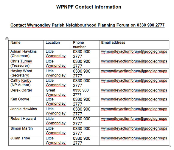
Wymondley Parish Neighbourhood Planning Forum (WPNPF)
Adrian Hawkins (Chair)
Adrian is the Chairman of Weldability Sif, a welding products business based in Letchworth Garden City, with a history dating from 1925. The company supplies distributors and major fabrication and engineering companies nationally and internationally. In 2015 it launched its state of the art Technology & Training Centre to support the training of much needed welders for this country. (Adrian has also created the Weldability Sif Foundation a registered charity to support vocational skills training in colleges across the UK; and he is Managing Director of Welding World a specialist magazine for the welding sector.)
He is passionate about Hertfordshire as he was born in Stevenage and lives and works in the county. He is the Chairman and Co-Founder of biz4Biz, an organisation established to support business owners and like-minded business people in and around Hertfordshire and has enjoyed the support of co-directors and many business professionals in raising the profile of the group. He is one of two SME Representatives on the Hertfordshire Local Enterprise Partnership (LEP) Main Board.
He is also a Governor of the North Herts College and Director, Trustee and Chair of Governors of the Hart Schools Trust. In the past four years, the Trust has been responsible for establishing two Da Vinci Studio Schools in Hertfordshire, one in Stevenage (Science and Engineering) and one in Letchworth (Creative); and recently welcomed The Thomas Alleyne Academy in Stevenage to the fold.
Chris Turvey (Treasurer)
Chris is recently retired, having spent in excess of 40 years in the construction industry, mostly as a Contract Manager/Director. His skill-set includes 12 years running Piling Contracts for developments requiring specialist foundation solutions where he was required to develop geotechnical expertise. Latterly in his career he was tasked with running contracts for flood damage insurance claims both for refurbishment and future proofing to mitigate possible future losses.
Chris has lived in North Hertfordshire for 32 years, the last 28 of which in Little Wymondley - within a community and area about which he cares passionately.
Hayley Ward (Secretary)
Hayley’s career for the past 21 years has been in marketing for various international business intelligence/events companies, working across several industries in that time, including commodities, financial services, law and architecture.
Hayley has lived in North Hertfordshire for 21 years, and chose to settle in Little Wymondley 18 years ago due to the character, ambience and community spirit of the village. Hayley is passionate about preventing the villages of the Parish from becoming part of “Stitchin” - whereby the areas around the towns of Stevenage and Hitchin become so developed, that they eventually form one huge town, with the villages of Wymondley Parish being swallowed up into this “mega-town” and losing their individual characters forever.
Cathy Kerby (NP Author)
Cathy took (very) early retirement in March 2009, having worked as a civil servant for 33 years. Much of that time was spent interpreting and applying legislation in a regional adjudication role; and subsequently working as a senior policy advisor for the Health and
Safety Executive, in areas such as Better Regulation, changing patterns of employment, and construction.
Born in Hertford, and having lived in the county all her life, Cathy became involved in Parish life about two years ago and now lives with her partner in Little Wymondley, where she enjoys village life and walking her dog through the surrounding fields and countryside. A keen genealogist, she is passionate about protecting our heritage and natural environment for future generations to learn from and enjoy.
Derek Carter
Derek is a retired teacher who has lived in Great Wymondley for 41 years, and is actively involved in village and parish life.
Ken Crowe
Ken has lived in the Hitchin area for most of his life, and has been a resident of Little Wymondley for the last 24 years. With children and grandchildren who live in the Parish, (the latter who attend Wymondley JMI School) he is particularly keen to ensure a sustainable future for them within the community.
Jennie Hawkins
Jennie has been employed as a Company Secretary, Finance & HR Director since 1981, working alongside her husband to establish a successful international business, based in Letchworth.
She has been living in the Parish for 17 years, having moved to Little Wymondley from Stevenage, and enjoys village life and the community spirit that exists locally. She believes the Green Belt is important to prevent the coalescence of major local towns; and strongly believes that maintaining the openness of the countryside is important for the wellbeing and happiness of the local community.
Robert Howard
Robert is a life-long resident of Little Wymondley, who owns a home here and wishes to remain for the rest of his life. He is an active and passionate member of the community, with a keen interest in its history, environment and way of life.
His local family history can be traced back to the early 18th century and, notably, two of his great-uncles gave their life serving their country and are commemorated on the World War 1 memorial plaque in St Mary’s church, Little Wymondley.
Simon Martin
Simon has worked in the Commercial Transport sector in excess of 30 years, managing workshops and commercial vehicle fleets. In the last 11 years he has worked for local government, managing many elements associated with fleet vehicles and, more recently, in Waste Management.
He moved to Little Wymondley in 2013 with his partner after a long search looking for the right house and location for their needs. Having found this they integrated into the community quickly, by actively joining in with social events and meeting people whilst also making new friends. The appeal of the village was its open spaces, accessible country walks and community spirit that fits in with their lifestyle.
Julian Tribe
Julian moved to Little Wymondley with his parents as a baby in 1973. Having moved away as a young adult, he always enjoyed visiting his parents, (who still live in the village). Julian moved back to the village in 2015, something he always wanted to do, and learned of the WPNPF group. He eagerly joined up, to help make the right decisions for the Parish based on the survey results, as he strongly agrees with preserving the Green Belt and maintaining the unique character of the Parish for future generations.
Annex 12
DOWNLOAD HCC FLOOD REPORT
To read the McCoys Flood Report